THE TRUTH ABOUT THE SAN PEDRO RIVER,
by JOHN D. ROSE.
WITHOUT QUESTION THE SAN PEDRO RIVER HAD A PROVEN, DOCUMENTED LACK OF SURFACE FLOW IN THE 19TH CENTURY.
WITHOUT QUESTION, THE QUANTITY OF COTTONWOOD TREES ON THE SAN PEDRO RIVER TODAY ARE FAR MORE ABUNDANT THAN WHAT EXISTED OVER A CENTURY AGO.
So has the growth of Fort Huachuca and Sierra Vista Arizona really reduced the River's surface flow, and diminished a nearly endless canopy of Cottonwood Trees? No, it has not. See the proof below.
The San Pedro River has been DAMMED REPEATEDLY, proving incorrect the claim that it is the last undammed desert river in the American Southwest. Why does this completely debunked assertion continue to be publicized? Anyone pursuing these truths can simply read published proof that this author has released over a period of the last FIVE years. If they can offer contrary historical proof, why haven't they?
DID THE SAN PEDRO RIVER REALLY FLOW BEFORE THE ARRIVAL OF SIERRA VISTA ARIZONA?
This has been confidently asserted in the press for a number of years. A number of groups have made this claim with great assurance to a public that understandably cares about environmental preservation. The San Pedro River has been DAMMED REPEATEDLY, proving incorrect the claim that it is the last undammed desert river in the American Southwest. Why does this completely debunked assertion continue to be publicized? Anyone pursuing these truths can simply read published proof that this author has released over a period of the last FIVE years. If they can offer contrary historical proof, why haven't they?
And this oft repeated claim is contradicted by actual photographs, and other contemporary evidence that show conclusively, without question, that the San Pedro River was dammed repeatably at a number of portions of it based on stamp milling, but especially farming operations.
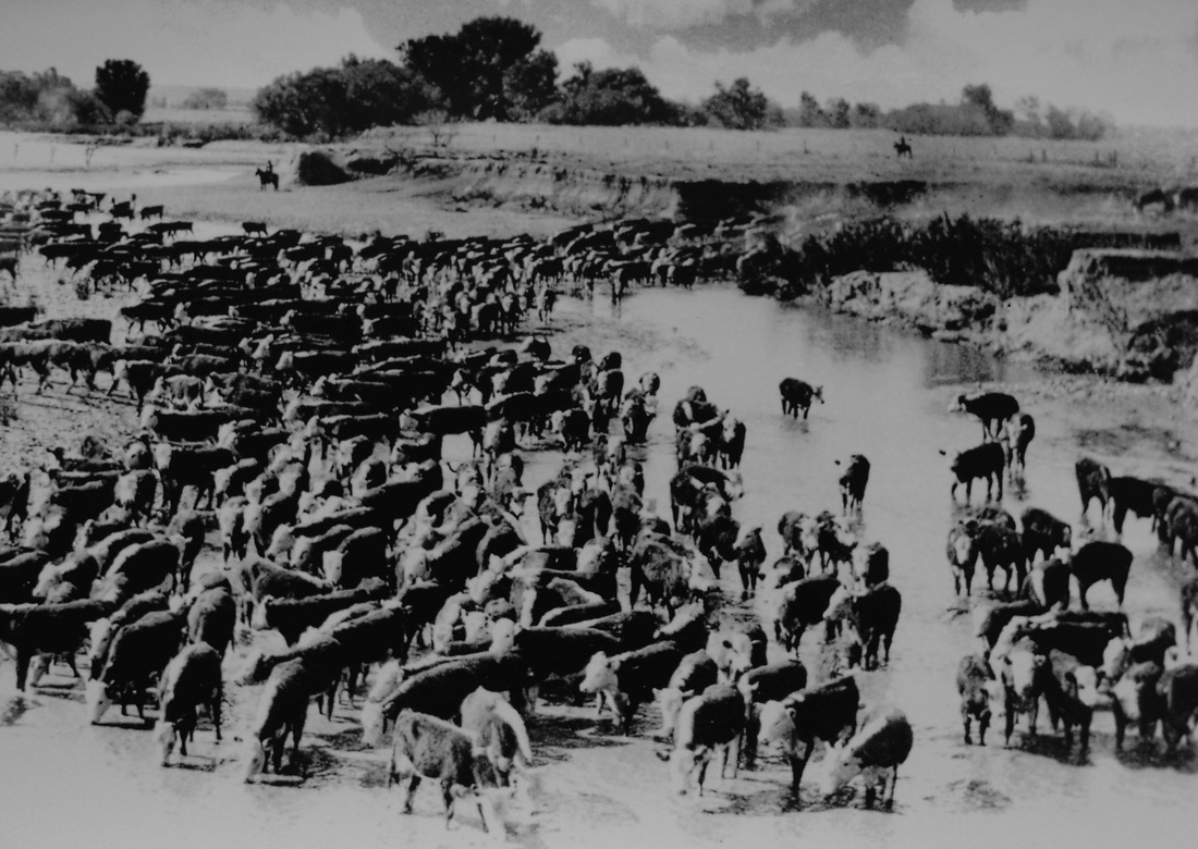
This also proves that for far too long, the historical record of the San Pedro River has been ignored, which proves conclusively that the river has been DAMMED REPEATEDLY, PROVING FALSE THE CLAIM THAT IT IS THE LAST UNDAMMED RIVER IN THE AMERICAN SOUTHWEST. IT IS NOT! Recorded history shows that it always had a lackluster surface flow, except during heavy rainful, and the near continual stands of Cottonwood trees are NOT HISTORIC, but rather from the 20th Century alone. And a new discovery has broken through this lack of information. It proves that long before the significant growth of Fort Huachuca and the founding of Sierra Vista Arizona, the San Pedro had a long documented history of scarce water flow at its surface. Now the San Pedro can be viewed with the benefit of new truths discovered in a 19th century court case by author John D. Rose.
And this oft repeated claim is contradicted by actual photographs, and other contemporary evidence that show conclusively, without question, that the San Pedro River was dammed repeatably at a number of portions of it based on stamp milling, but especially farming operations.
This also proves that for far too long, the historical record of the San Pedro River has been ignored, which proves conclusively that the river has been DAMMED REPEATEDLY, PROVING FALSE THE CLAIM THAT IT IS THE LAST UNDAMMED RIVER IN THE AMERICAN SOUTHWEST. IT IS NOT! Recorded history shows that it always had a lackluster surface flow, except during heavy rainful, and the near continual stands of Cottonwood trees are NOT HISTORIC, but rather from the 20th Century alone. And a new discovery has broken through this lack of information. It proves that long before the significant growth of Fort Huachuca and the founding of Sierra Vista Arizona, the San Pedro had a long documented history of scarce water flow at its surface. Now the San Pedro can be viewed with the benefit of new truths discovered in a 19th century court case by author John D. Rose.
In 1889 a group of ranchers, farmers, and stamp mill owners went to court with each other. At issue, the weak supply of water in the San Pedro River, and just who had the right of ownership to this scarce supply. This court case, known as Hill vs. Herrick, is a recently discovered breakthrough that offers never before seen sworn testimony. It delves deeply into the reality of the river long before the arrival of the modern age and these claims about the river that history disproves. This testimony occurred in 1889, over 60 years before the founding of Sierra Vista Arizona.
Today Sierra Vista has widely been purported to be the cause of the scarce surface flow of the San Pedro River. And yet, the Hill vs. Herrick case proves that in 1889, the same problem plagued those living and working along the river even then. How do those who make such statements regarding Sierra Vista’s impact on the San Pedro explain this official court record, and its historical impact? If they wish to argue that Sierra Vista has indeed caused the river’s reduction in flow, then how do they explain a lack of water flow in the 19th Century over 50 years before the creation of Sierra Vista? What would they assert caused that?
By 1889 the economy of Tombstone has crashed, and with it a substantial population decline. But even before Tombstone, a stage station on the banks of the San Pedro River, (aptly named San Pedro Station) was without water. This station was used on the “Butterfield Stage line,” then known as the Overland Mail. Seventeen years before the arrival of Tombstone, and its mill towns along the San Pedro, such as Charleston and Contention, this stage stop located at the San Pedro River had no water available to travelers, as the river was dry at that location. The historical record documents this lack of water in the river numerous times, arguing that the San Pedro never had a strong surface flow unless it was in flood stage from large rainfall, just as it is today.
In light of this record, how then can it still be asserted that Sierra Vista has caused this purported decline in the surface flow of the river? The discovery of the Hill vs. Herrick case is a major breakthrough in the historical study of the San Pedro River and the San Pedro River Valley. The case offers much insight into the day to day lives of so many who toiled up and down the river as teamsters, construction and mill workers, and residents of Contention City, Fairbank, Charleston and Millville, and all of these near forgotten ranches and farms that dotted the banks of the San Pedro in between and beyond those points.
The era of settlements and small ranching/farming operations along the San Pedro was not destined to be a long one. Many settlers thought they were on public lands, or at least said so, but it was in the press many times that there was an issue that much of the San Pedro River lands south of Benson and nearing the Mexican border were actually situated on two Mexican land grants. Those who made their livelihoods there, paid taxes there, and endured hardships such as drought conditions, flooding, and a dwindling supply of the overburdened and limited flow of San Pedro River surface water, would later find that these land grants were of real consequence.
Old myths sometimes have been joined by contemporary ones. The Hill vs. Herrick case disproves a recent claim that by 1881 when George Hearst and Robert Howard had gained control of the San Juan de Boquillas y Nogales land grant, the entire area, over 17,000 acres, became an outdoor “time capsule” frozen in time, with no one living in the area unless they had Hearst’s blessing, making for a sparse population. In reality, this area remained vigorous and vital with substantial settlements and agricultural commerce well through the 1880’s and into the 1890’s. It wasn’t until 1899 that this dynamic would see its underpinnings stripped away as the new owners of the grant began to enforce their property rights in a way that George Hearst had never chosen to.
A WINDOW INTO THE 19TH CENTURY SAN PEDRO RIVER
“A vast marsh, a cienega, spread out miles and miles ringed with hardwoods.” -Excerpt from a 2012 article regarding the San Pedro River.
It was within the last ten or so years that the branch campus of Cochise College, located in Sierra Vista, Arizona, asked me to drive a tour down to Cananea, Sonora, Mexico. It was an opportunity that I readily accepted as it’s such an aesthetic and historically important area. The chance to walk through Colonel W. C. Greene’s home which still stands there, as well as visit the mining operation, was one I could not refuse. I wanted to learn more if possible about the San Pedro River, the water way that originates near Cananea, and then flows into the US. On this very worthwhile visit our guide knew well the issues that related to the river, as well as the international implications of water use on the Mexican side and its effect on the amount of water that reaches Arizona after originating in Mexico.
Among the sites we took in on our day trip was a city street with a fountain. The area that the street traversed was not level, and our guide noted that water drainage flowing down one side of the street headed to a wash that led to the San Pedro River, and the water flowing down the other side went to a different destination. He jokingly added that the fountain nearby was a reminder to Americans that those in Mexico had first access to the waters of the San Pedro. He was of course correct. “See, we’re using water that would have gone to the San Pedro to fill that fountain,” he said.
It was all in good nature, but a point of truth had been well made by our guide. The San Pedro is an international waterway, affecting the lives of the citizenry of two neighboring nations, and we in the U.S. have to acknowledge the obvious. These waters do not originate on our lands, so we don’t own it at its inception. This river originates from many tributaries in the Sierra Madre Mountains, meeting to form the San Pedro just fifteen miles south of the US/Mexico border. It slowly wends its way north, both above and below the ground, till it reaches the Gila River near Winkelman, Arizona. It should further be noted that the U.S. has drained much of the Colorado River before it reaches Mexico.
A RIVER OVERFLOWING WITH MYTHOLOGY AND LACKING IN WATER
The San Pedro River was dammed more than once in the 1880's.
The San Pedro River was dammed more than once in the 1880's.
Today’s mythology of the San Pedro River has reached unprecedented levels of acceptance in the public discourse. The river has often been referred to as “One of the last great places,” as indeed any source of self-sustaining water found in the desert must be considered special. It has also become a rallying point for environmentalists who reside locally, and others who are far removed from the region that such a debate affects.
Hill vs. Herrick and earlier accounts of explorers passing through the area further disprove the fables of paddle wheel steamers and barges floating up and down a once mighty San Pedro River (as I was taught in local schools as a child). It illustrates instead a surface flow of the river 130 years ago and earlier that is similar to the flow of today. This is drawn into sharp focus in repeated testimony that documents a number of dams up and down the river, built in attempts to corral the scant surface flow of the river and send it into ditches that transported it to nearby crop fields. When working properly, any extra or waste water was sent back into the river via a return ditch to continue its northward meandering so that others could use the same. But increased settlement as the 1880’s progressed, and reduced rainfall, stressed this already meager supply, turning neighbor against neighbor, and busying a court reporter from Tucson whose duty it was to type well over 1000 pages of testimony on which this book finds its greatest window into a past that otherwise would be lost to the ages.
This important case is not the only source of information about San Pedro water flow. On July 25th, 1880, Tombstone diarist George Parsons headed for Millville and Charleston with friends. Parsons wrote that he was asked “to go swimming with them at Charleston or near there…At Charleston are the Gird and Corbin Mills - both stopped for lack of water. The San Pedro is anything but a mighty stream. One can jump across most of the rivers of Arizona and California I guess…”
Tombstone diarist George Parsons. His journal has long been an important resource to historians given his detailed and accurate descriptions of the historical record.
IS THE SAN PEDRO RIVER REALLY THE LAST UNDAMMED RIVER IN THE SOUTHWEST?
SAN PEDRO RIVER DAM NEAR CHARLESTON IN 1880 BELOW.
SAN PEDRO RIVER DAM NEAR CHARLESTON IN 1880 BELOW.
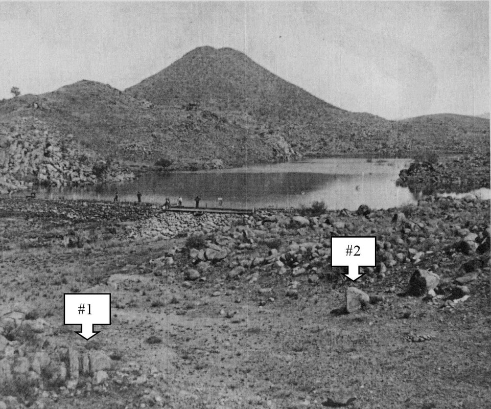
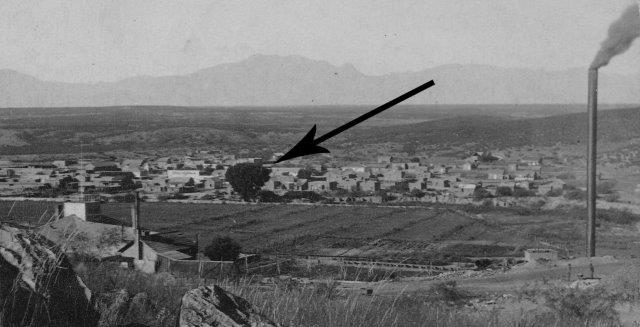
The black and white photo above was taken by Carleton Watkins in the spring of 1880. The numbers 1 and 2 have been added marking rock formations that prove this is the exact location of the Charleston Dam. After visiting Millville Parsons added that “on we went several miles to the dam which we found had given way. No chance for a swim.” The scarce surface flow that Parsons noted even when the dam was absent proves false today’s conventional belief that the San Pedro River had far greater flow in the 1880’s than it did in the 20th Century.
Six years later in the summer of 1886 Parsons was conducting a trip which included a leg along the San Pedro River. Reports of Indian sightings were common at this time; Parsons was hoping to dodge any chance meetings with Apaches and Geronimo. On June 15th, he “lunched at St. David” noting that “The Mormons treated us well…I left others here and went to Benson for promised military escort.” On Thursday, June 17th, a jumpy Parsons needed a bath and his horse was in need of a rest. “Good bath in [the] San Pedro River this afternoon. Water didn’t quite cover me lying down, but had a good wash meantime keeping lookout for Indian.” It is noteworthy that prior to the summer rainy season, water flow in the river was scant, barely able to cover someone lying down in it.
Six years later in the summer of 1886 Parsons was conducting a trip which included a leg along the San Pedro River. Reports of Indian sightings were common at this time; Parsons was hoping to dodge any chance meetings with Apaches and Geronimo. On June 15th, he “lunched at St. David” noting that “The Mormons treated us well…I left others here and went to Benson for promised military escort.” On Thursday, June 17th, a jumpy Parsons needed a bath and his horse was in need of a rest. “Good bath in [the] San Pedro River this afternoon. Water didn’t quite cover me lying down, but had a good wash meantime keeping lookout for Indian.” It is noteworthy that prior to the summer rainy season, water flow in the river was scant, barely able to cover someone lying down in it.
Today, Parsons account regarding the dam near Charleston is at odds with some public statements about the river, as well as the late 19th century photographic record. The oft repeated claim that "The San Pedro River is the last undammed desert river in the American Southwest" needs further clarification. Here's why. It is true that today, in the Twenty First Century, the San Pedro is no longer dammed, and it has not been dammed in recent history. But many are surprised when being introduced to photographic proof that the river clearly was dammed prior to the modern era. And I've been asked, why is it repeatedly stated that the river is undammed, when it clearly has been. According to Wiktionary, the definition of "undammed" is "Not having been dammed." If this statement acknowledged that "Though the San Pedro is undammed today, it has been dammed in the 19th century many, many times," this would be correct.
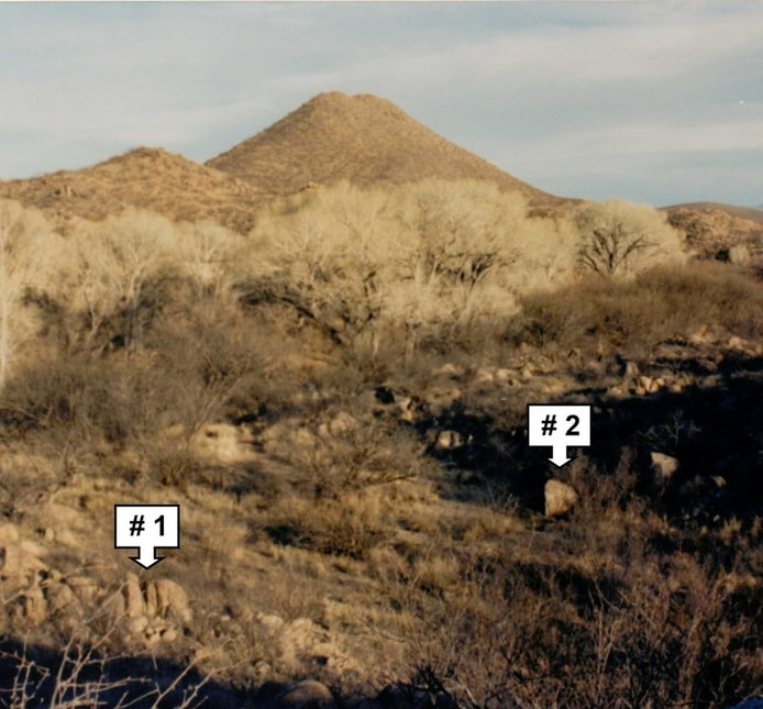
And these photos above and below prove that the San Pedro River was dammed in 1880, and many other times as well. The color photo below shows the exact same rock formations, in the exact same locations, proving that this indeed is a modern day photo of the original Charleston dam site. Photo taken by John D. Rose in the 1990's.
And these photos above and below prove that the San Pedro River was dammed in 1880, and many other times as well. The color photo below shows the exact same rock formations, in the exact same locations, proving that this indeed is a modern day photo of the original Charleston dam site. Photo taken by John D. Rose in the 1990's.
THE SAN PEDRO WAS DAMMED NEAR CONTENTION CITY IN 1879
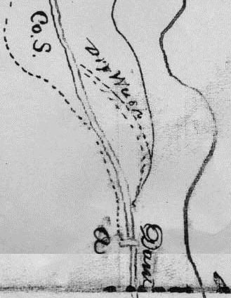
Below: William Drew, Founder of Drew's Station, near the San Pedro, drew the map below, during the court case of "Drew vs. Mason." The case was over disputed water rights, and near the bottom of the map Drew notes a dam located in the area north of Contention City. Map courtesy of AHS.
Below: William Drew, Founder of Drew's Station, near the San Pedro, drew the map below, during the court case of "Drew vs. Mason." The case was over disputed water rights, and near the bottom of the map Drew notes a dam located in the area north of Contention City. Map courtesy of AHS.
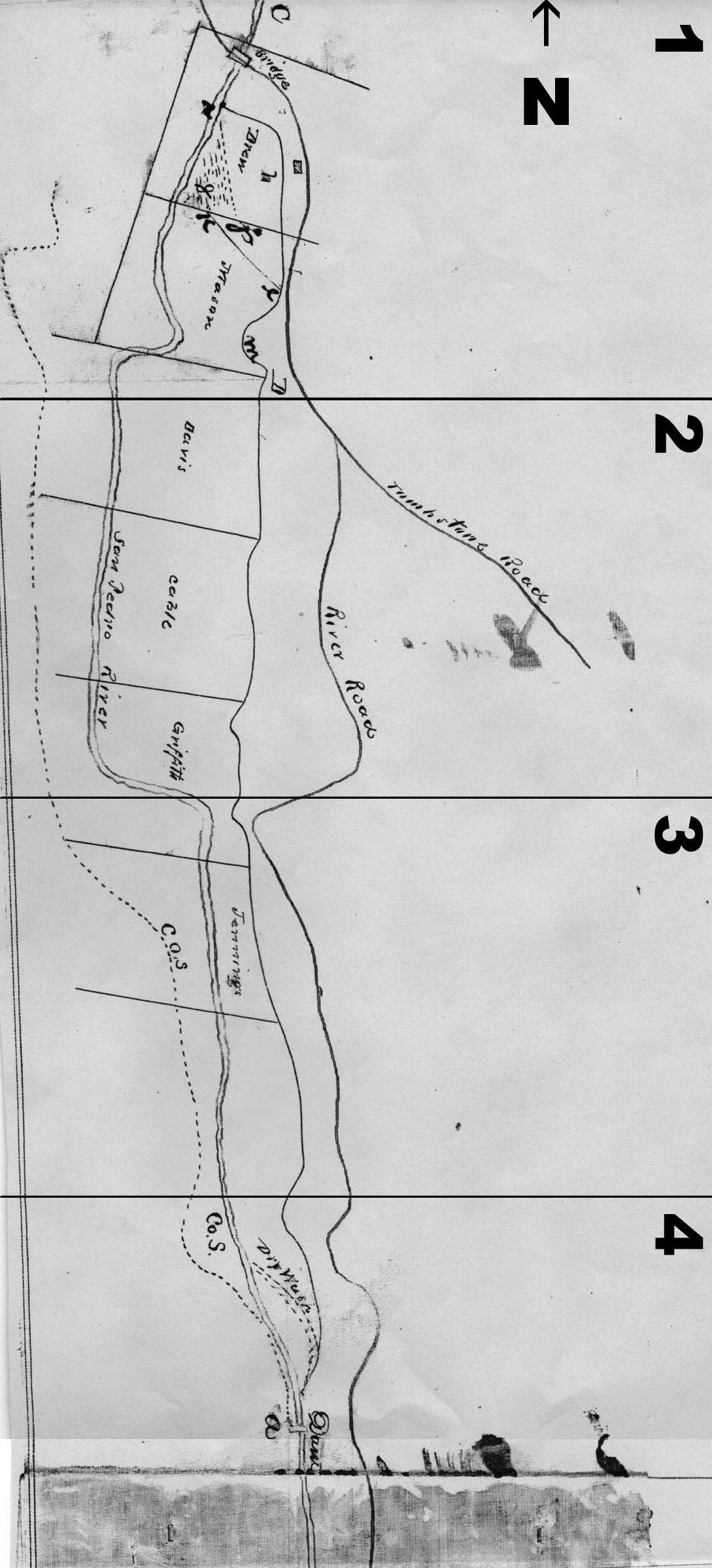 Above is a cropping from the bottom of William Drew's map. Note that his placement of the dam is near the very bottom of the drawing, and that the dam completely blocks the river.
NO WATER IN THE SAN PEDRO RIVER IN 1859
The Weekly Arizonian(see below) would also record in 1859 which stage stations, along what is now commonly referred to as the Butterfield Stage route, had water and which did not, for the benefit of travelers. They reported that the San Pedro Station, which was built so close to the river that the waterway later consumed the site, was without water in 1859, long before Tombstone was even discovered and major settlements sprang up along this key, but very limited, water way. Travelers arriving in Tombstone sometimes told of having to wait to cross the river during its flooding, which only occurs after a substantial rainfall. This also proves incorrect claim that the river had a much greater surface flow before settlement and related well drilling occurred.
The Weekly Arizonian(see below) would also record in 1859 which stage stations, along what is now commonly referred to as the Butterfield Stage route, had water and which did not, for the benefit of travelers. They reported that the San Pedro Station, which was built so close to the river that the waterway later consumed the site, was without water in 1859, long before Tombstone was even discovered and major settlements sprang up along this key, but very limited, water way. Travelers arriving in Tombstone sometimes told of having to wait to cross the river during its flooding, which only occurs after a substantial rainfall. This also proves incorrect claim that the river had a much greater surface flow before settlement and related well drilling occurred.
Today the San Pedro River still travels from the south to the north just as it always did, inspiring present day myths from romantics who divine a more dramatic history of this waterway. In 1858, James B. Leach of the Department of the Interior was enlisted to supervise the construction of a roadway through southern Arizona. “Leach and his companions had a surprise in store for them as they traveled down the San Pedro about 35 miles below Tres Alamos [north of present day Benson, where Billy Ohnesorgen had a stage stop. This places Leach in the area of Lewis Spring, just south of Charleston, which has been a long term source of water on the San Pedro] on September 12:
“‘The train was ordered forward at 7 a.m. Exceedingly to the surprise of every member of the expedition who had passed over this route in the months of March and April it was discovered after a march of a few miles that the waters of the San Pedro had entirely disappeared from the channel of the stream. The discovery was first made by Col. McKinnon, Paymaster, who returned to Camp reporting according. So incredulous were many of those who were on the April Expedition that heavy bets were offered that Col. M. was mistaken. A thorough examination proved his discovery correct much to the astonishment of many. Where the present reporter took quantities of fine trout in March and April 1858 not a drop of water was to be seen. The same circumstance (the sinking of the waters of the San Pedro) however, is referred to in Lt. Parkes journal of his expedition through this country.’”
It is further asserted that the grand stands of cottonwood trees that so majestically line the river at present are of ancient origin, ignoring the fact that photos taken in the historic period contradict some of these claims.
Mary Wood, wife of an important mining executive, would leave behind a credible account, her dates and figures standing up well against historical scrutiny. She recalled only one cottonwood tree in the Charleston and Millville area, and made note of it: “My first view of Millville in the fall of 1880 was a pleasant surprise for their nestling against the hills which closely circled it on the north and east was a lovely alfalfa patch of several acres. On the western edge on the banks of the San Pedro River was a very large cottonwood whose leaves were still a vivid green…It was the first green I had seen since leaving California.”
ONLY ONE COTTONWOOD TREE AT CHARLESTON IN THE 1880's INSTEAD OF THE MASSIVE STAND OF COTTONWOODS THAT EXISTS THERE IN 2017
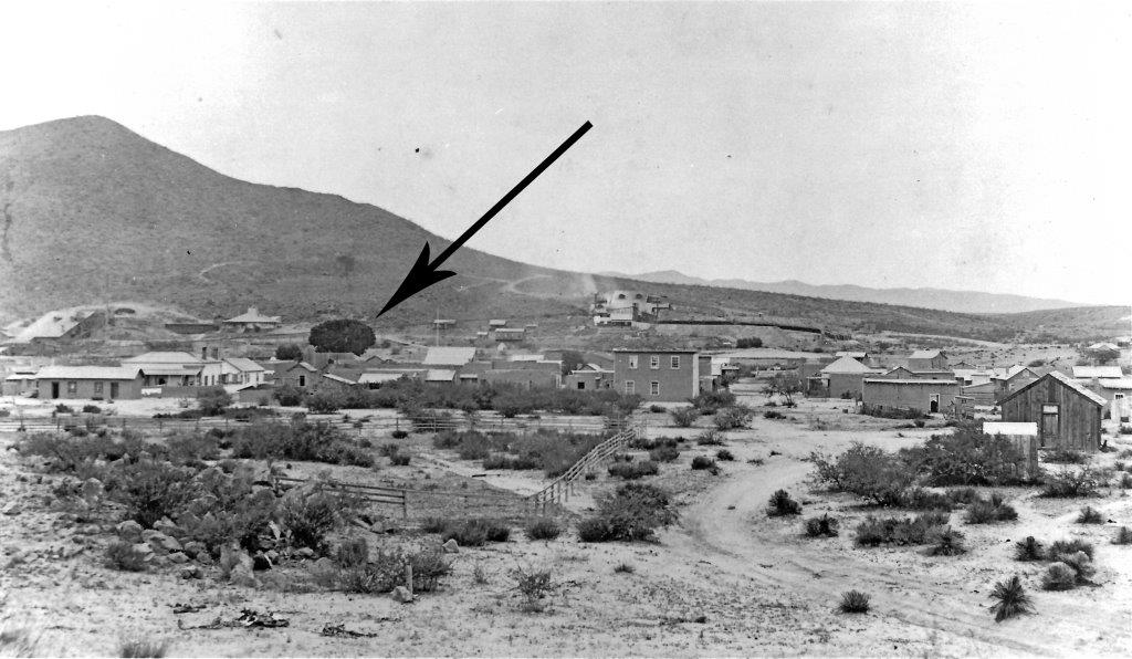
The arrow notes the large Cottonwood sat Charleston that Mary Wood recalled. Copy photo from the collections of John D. Rose.
The lone Cottonwood at Charleston marked with an arrow from the opposite direction, looking toward the Huachucas. Cropped from the original stereoview in the collections of John D. Rose.
Assertions that the massive stands visible today were there, and Tombstone and Charleston settlers cut them down for housing or to burn in stamp mills is an attempt to extrapolate “facts” from information that does not exist. Photographic evidence from the day conclusively proves Mary Wood right, as there is one cottonwood visible in the early 1880’s at Charleston, and nothing else. That is not to say that there were no stands of cottonwoods in the San Pedro River Valley.
At first glance, eye witness historic accounts of the flora of the San Pedro may appear contradictory. Some explorers speak of stands of willows and cottonwoods, while others searched to find a line or stand of trees to guide them to the river, only to practically fall into the river without that benefit.
But in reality, it may well be that such accounts are not contradictory at all. Once the Tombstone District gained momentum, settlers began dotting the map with sites such as Charleston, Millville, The Boston Mill, Fairbank, Ochoaville, Contention City, Drew’s Station, and intermittent ranches and farming operations. From such known locations references were made to stands of trees, or the lack thereof, along the river. But prior to such settlements, less markers existed on the ground, giving such accounts a more general reference in some cases. The founding of the Tombstone District marked the first major development of the San Pedro River Valley, an area largely untouched prior to that, as incessant Apache raids ran off the preceding attempt to colonize the area under the banner of Northern New Spain.
What is clear is that an eye witness along one portion of the river may well have seen plant life that another eye witness in another area of the river did not. That there were pockets of cottonwood and willow trees in given areas along the San Pedro River is clear. What is equally established, not only through written accounts but also through late 19th Century photography, is that the uninterrupted stands of cottonwoods following the river for miles did not exist.
This idea that the cottonwood stands of today are centuries old has become established as fact in the minds of many, gaining press as they continue to be propagated, resulting in the impression that these stands of trees will become endangered as Sierra Vista continues to pump ground water and aquifer waters from the Huachuca Mountains. Many already assert that the city and fort’s use of water has diminished the flow of the San Pedro River, which presents a danger to the wildlife which both lives there and migrates through, and to the trees.
THE PRESS OF TODAY AND THE SAN PEDRO RIVER
The University of Arizona press has published “The San Pedro River A Discovery Guide” by Roseann Beggy Hanson. In promoting the book, this prestigious press notes that “It’s little wonder that the San Pedro was named by the Nature Conservancy as one of the Last Great Places in the Northern Hemisphere, and by the American Bird Conservancy as its first Important Bird Area in the United States. Roseann Hanson has spent much of her life exploring the San Pedro and its environs and has written a book that is both a personal celebration of and a definitive guide to this, the last undammed and unchanneled river in the Southwest.”
The statement that says the San Pedro is “the last undammed and unchanneled river in the Southwest” confuses the facts of the river’s history. It is true that as of the date of Hanson’s book in 2001, and as of this writing the San Pedro River is undammed and unchanneled. But it may leave the reader with the mistaken impression that part of its status as “One of the Last Great Places” is that it was never dammed, and therefore it remains in an untouched, pristine state.
This promotional article continues, “In addition, the river supports one of the largest cottonwood-willow forest canopies remaining in Arizona.” This may well be true, but it should also be pointed out that this canopy as it exists now is not of an historic nature.
I was asked in the 1990’s to give a lecture on the history of the San Pedro River to a group of volunteers who would be guiding tours along the river for those who wished to know in-depth, accurate information. At one point, the facilitator of the lecture interrupted, asking me to explain how the Tombstone settlers cut down the cottonwood trees to help build homes in Tombstone, and to burn in the mills at Charleston. Historical records show the locations and operations of wood mills in the Huachuca and Chiricahua Mountains, as well as in the Dragoons, for those purposes, but indicate no wood cutting along the river. Paul De Martini owned a farm on the Babacomari, and later farmed on the San Pedro River just above Fairbank in the 1880’s. He spoke of willows on his San Pedro property, and described building a home on that land. In order to build his log house, he brought lumber and other wood from the Babacomari (not the San Pedro). If there were trees along the river more suitable for building the type of structure he had in mind, one would suppose he would cut them there rather than hauling them back from the Babacomari. T.S. Harris hauled lumber from the Huachuca Mountains for use in building the mills along the river. H.C. Herrick went to the Chiricahuas to buy lumber for the construction of his flume.
A much earlier account speaks of the flora around the vicinity of where Charleston would be located. “The Mormon Battalion was still marching north of December 11 [1828] when an encounter took place with bulls close to the present location of the ruins of the mining town of Charleston…‘The land on each side of the Pedro River bottom is a dense thicket of bramble bush, mostly muskeet, with which millions of acres are covered.’” Mr. Keysor, who wrote that observation within his broader description of the “Battle of the Bulls,” was probably exaggerating with “millions of acres,” but he did not name any cottonwoods. Robert Upton, a teamster in the 1880’s, described large and dense thickets of willows in the area of the narrows by Charleston.
Other early accounts describe the river landscape in varying conditions long before the era of settlements. Colonel Stephen Kearney of the California column created the first accurate map of the region between the Rio Grande and Pacific Ocean. In 1848, his Lt. William Emory described the valley at the mouth of the San Pedro where it empties into the Gila River. ‘“The valley of this river is quite wide, and is covered with a dense growth of mesquite, cottonwood, and willow, through which it is hard to move without being unhorsed…The San Pedro [is], an insignificant stream a few yards wide, and only a foot deep.’” James Leach confirms this report with his own observation of the San Pedro at Aravaipa (just south of Winkelman on the lower San Pedro): “‘The waters…were found full of fish, large numbers being taken daily, during our stay on the stream…Extensive forests of Cottonwood and ash lined the banks of the river and the adjoining Mesas and arroyos were natural pasture fields for countless herds and flocks. (Leach 1858)’”
Leach commented on the landscape at Tres Alamos: “‘A forest of heavy mezquite timber about one mile in width extends from the river…Leaving the forest it [the river] enters upon a tract of the bottom lands of the San Pedro…In March 1858 the entire body of these lands were covered with a dense growth of sacaton grass averaging four feet in height and dry as tinder. Fire was communicated to it at a point about 20 miles below the site of Camp No. 14 [no specific location is given] and the entire length of the Valley of the San Pedro was traversed by the flames consuming every vestige of this once luxuriant growth. A much to be regretted attendant circumstance of this conflagration was the destruction of large quantities of Cottonwood, Ash and willow timber with which the banks of the river were densely overgrown. In three weeks after the occurrence of the fire it may be remarked that the Sacaton grass had grown up and covered the entire valley with a beautiful carpet of verdure (Leach 1858).’” Cottonwood are mentioned, but only in general terms in the area of the fire, which traveled the river for miles.
In September of 1851, John Bartlett was traveling west, “…crossing north of the Dragoon Mountains into the San Pedro Valley, probably following Dragoon Wash. [This would put him somewhere between Tres Alamos and present day Benson.] Bartlett wrote: ‘On emerging from the arroyo, we entered a plain, thickly overgrown with large mezquit bushes, but destitute of grass. We looked in vain for a line of trees, or of luxuriant vegetation to mark the course of the San Pedro – when all of a sudden we found ourselves upon its banks. The stream…was here about twenty feet across, about two feet deep, and quite rapid…’” Bartlett was describing the river after a rainstorm.
Cropped from the original map by John G. Parke, from the collections of John D. Rose.
"The flow of water, however, is not continuous." - Lt. John Parke, 1855.
Lt. John Parke described the area north of Tres Alamos in the summer of 1855. He was at that time surveying the San Pedro between the area of Tres Alamos and its mouth at the Gila River: “‘In the gorge below [Tres Alamos] and in some of the meadows, the stream [bed] approaches more nearly the surface [of the floodplain], and often spreads itself on a wide area, producing a dense growth of cotton-wood, willows and underbrush, which forced us to ascend and cross the out-jutting terraces. The flow of water, however, is not continuous. One or two localities were observed where it entirely disappeared, but to rise again a few miles distant, clear and limpid…’”
Parke observed the river near the present site of Benson in February 1855. “‘The stream is about eighteen inches deep and twelve feet wide, and flows with a rapid current, at about twelve feet below the surface of its banks, which are nearly vertical, and of a treacherous miry soil…The banks are devoid of timber, or any sign indicating the course or even the existence of a stream, to an observer but a short distance removed…’”
Approaching the U.S. Mexican border in 1857, William Emory, now a Major, had this to say about the upper San Pedro: “‘At this point [on the International Boundary], approaching from the east, the traveler comes within a mile of the river before any indications of a stream are apparent. Its bed is marked by trees and bushes, but it is some sixty or one hundred feet below the prairie, and the descent is made by a succession of terraces. Though affording no very great quantity of water, this river is backed up into a series of large pools by beaver-dams, and is full of fishes…’”
It is clear, as explorers described this river region moving north to south, that the environments along the river are unique in vegetation and water flow. From Davis’ book alone, there is substantial evidence that water flow in the river was inconsistent and limited, and that cottonwood trees appeared in particular areas but not completely lining the river.
With the history of lawsuits against Fort Huachuca and also the enjoyment many in Sierra Vista derive from visits to the river, an article was recently published in the Sierra Vista Herald Dispatch about the San Pedro and efforts to further its study.
The article echoed what has now become an accepted refrain. Local writer Shar Porier offered the following summary of the river. “What it boils down to is what was said to me over and over again-everyone living in the San Pedro River Basin has to care about this narrow, sliver-green band of life that astoundingly flows almost continuously in a high desert environment providing life to creatures that crawl, hop, trot and fly-and us as well.”
She continues, “Where would we be without this river that draws people from around the world to seek the feathered avians that find their ways here every year on migrations to every corner of North America?” These are valid points, as many in the area, including myself, are proud of the San Pedro River and what it offers as a natural resource not only to our area but others as well, since various species use it as a corridor. Such nature enhances all of our lives. At the same time, the other point that many Sierra Vista residents would raise is, “Where would we be without Fort Huachuca?”
The missions of the fort are of strategic significance. Many in the area are also proud of the ample contributions of the men and women who wear their nation’s uniform here, and are ready to sacrifice all if their country requires it of them. Both of these views should be able to coexist in harmony. All who live in the San Pedro River valley must surely understand that our national security, of which Fort Huachuca plays its own part so importantly, allows all of us to enjoy the natural beauty of our area without concern for the safety of our families.
Part of gaining harmony in the area is the establishment of a baseline of facts about the river. That baseline, which for far too long has been woefully neglected, is the historical record that has been waiting to be told. And Porier asks the following question. “Or maybe the more valid question is where would they be [the migrating species that frequent the San Pedro] without this feisty river born from a gentle wetlands hundreds of years ago?
How that must have looked,” she continued. “A vast marsh, a cienega, spread out miles and miles and ringed with hardwoods. It’s hard to even conceive that picture now. The San Pedro River valley cienega is gone for the most part.”
From the perspective of recorded history, what the river area was like hundreds of years ago is hard to say, as it precedes the written historical record. It is clear though, that by the 19th century, the area had evolved to the conditions of travelers’ and ranchers’ descriptions in those times. The testimony from the Hill vs. Herrick case makes it clear that small cienegas existed in pockets here and there along the river, but not as a vast swampland. The substantial stands of hardwoods speculated upon that once ringed the San Pedro were no longer present, either. So that vast cienega and forest of hardwood trees no longer existed by the time pioneers began coming into and through the area. If they had ever existed, they were lost for reasons other than human intervention, such as wood cutting and settlement. It would be inaccurate, therefore, to blame early settlement along the river for that loss.
To be clear, author Hanson and writer Porier are by no means alone in publishing such statements. But regardless of such claims, at some point between 1880 and the present a change has occurred within the river environment which encouraged the proliferation of the cottonwood trees. Some in the environmental movement believe that preserving this relatively new phenomenon is more important than keeping alive an entire community that owes its existence to the substantial payrolls of Fort Huachuca.
At the opposite end of the spectrum, there are those who would wish to see substantial development. This unbalanced approach to land use would only grade into oblivion much of the wide open spaces that give the area its appeal. It may also diminish the water from aquifers which have been supplying this area, upon which Sierra Vista now sits, with water for over 100 years. (Sierra Vista was officially established in 1956, but settlement of the area long preceded the founding of this mid 20th Century city.)
On February 15th, 2013, the Wall Street Journal reported, “A Water Dispute Nears a Boil in Arizona.” Castle and Cooke Inc., a Los Angeles based real estate company, has proposed a 7,000 home development (in Sierra Vista) which would “pump roughly 3,000 acre-feet of water a year from state land near the San Pedro…to service its new residents. (One acre-foot is generally taken to represent annual water usage of a suburban household.)” The Bureau of Land Management, some landowners, and environmental groups are fighting the proposal. In between these extremes are those who enjoy the river, enjoy their homes and the quality of life that the Sierra Vista area provides, and believe that the San Pedro River, Sierra Vista, and Fort Huachuca can all exist together and without continual strife.
A DISINTERESTED PARTY SPEAKS TO THE COURT
“I don’t think they have sufficient water to irrigate for corn now…” –W.W. Woodman
“I don’t think they have sufficient water to irrigate for corn now…” –W.W. Woodman
And one of the more remarkable aspects of the Hill vs. Herrick case is that the court was so diligent in wanting to understand the truth about the water flow in the San Pedro, that they initiated a water study. This documented, thoughtful effort is a rarity. Though it cannot be considered scientific, especially by today’s standards, it is a far from typical indeed. Instead of gathering bits of information in reports or diaries or newspapers this effort focused strictly on recording the water in the San Pedro in 1889 in as great a detail as possible for the time.
The court had wisely sent its own representative, W.W. (Warren Walter) Woodman, to see for himself the conditions of water flow along the San Pedro, view ranches and farms, and speak with owners involved. He took special notice of the condition of their fields and the crops that they grew there. They also conducted nonscientific water manipulation studies, measuring the water level in a given area of the river, closing down irrigation systems upstream, then going back to the same measured point and remeasuring, to make note of any differences.
At times the differences measured were minimal to say the least, and the findings were occasionally at odds with each other. But he did offer a brief synopsis of the intermittent nature of San Pedro River surface flow. “…one place there will be no water and then you go a little ways further and there you find water that can be taken out, and so on a little further. Everybody knows that that travels up and down the river.”
This is important as Woodman testified that there wasn’t at all a constant flow in the river. Rather, there were dry patches that ran until coming to a wet one. This is similar to today. And this further disproves that the river had a full flow prior to the founding of Sierra Vista. In fact, it had sparse flow eleven years before the dawn of the 20th Century, in 1889.
He visited ranches further north on the San Pedro, those located on the Union Ditch. Woodman’s observations created a temporary fracture between two parties on the same side of the suit, neighbors John Hill and Andrew Summers. One morning while riding along the river, Woodman noticed a head of water coming out of the Summers ranch (above Hill’s), running into the river, bypassing the irrigation ditch that fed Hill’s and Clifford’s places.
Woodman pointed out to Hill that water was running into the river that was being wasted, and given the related controversy and lack of water in general, it was self-evident that this was less than desirable. Summers blamed his horse. Woodman testified, “I told Mr. Hill that under the present condition of the water it would not do to let any run into the river, and he said he would go and give Summers hell about it, and the next time I saw him Mr. Summers explained, or had explained, that the horses in the pasture had forced the top of the board off the gate and let the water down.” This wasn’t the only case of waste that Woodman observed. “One time from Clifford’s place a small stream was running out one morning,” running to waste. It’s the same water that “…runs down the centre of the slough that runs through the centre of the Hill and Clifford places.”
Important to his testimony was Woodman’s emphasis to the court that he truly did not want to appear that he was in any way advocating for or against anyone involved. His words do read true to this ethos, and it would appear that his visits gave him an understanding that few court officials in the hearing may have had. It may have surprised him as well, as he spoke eloquently to the water needs of many on both sides of the controversy.
Woodman testified that H.C. Herrick was suffering for want of water. “Well, I haven’t seen much waste water on Mr. Herrick’s place. He has had very little water…very little water indeed, while I have been there.” Woodman was then asked about Mr. Storer, who was so harshly handled by attorney Goodrich, and his water use. “I haven’t been through it this year, but I don’t think he wastes any water. It is my impression that what water he loses gets back into the creek [San Pedro River].”
He also shared an unusual description about Storer’s system at the Boston Mill site, and the source was Storer himself. “…he has a flume that runs right under the river. I haven’t seen it, but he tells me about it…in very bad condition, leaks a good deal. I told him it wasn’t my fault. From what I know of his ranch there can’t be but very little waste on his farm because he has got too much of it…Mr. Storer needs some water more than he has. He has a pasture field that I go by every day that would be benefitted by water.”
Woodman was then asked if he took notice of John Hill’s oat field. “…it needs water, and he has since given it water, I believe…I don’t think they have sufficient water to irrigate for corn now…I don’t wish it understood at all in my testimony that I have said or am willing to say that these people down there have had all the water that they need at this time of the year.”
Because of Woodman’s previous experiences with farming and irrigating, he was able to offer an interesting theory as to how ranchers could most benefit from the limited waters of the river. His testimony indicated that there was a fair amount of water wasted on some of the ranches. He was asked, “From your experience and what you have observed along that river what is your opinion, if the water was properly used, as to there being a supply for them all above Charleston, on that river?” Woodman was tentative in his reply: “…more economy could be practiced in the use of water than there is now.” “If that economy was used would there be enough for all practical purposes for ranchers up there?” “I undertake to say that there would be no very great suffering. Of course, at this time of year a man might lose a crop or a portion of it, but if they would begin in the fall…” The court asked, “Suppose people would all saturate their land thoroughly in the winter months, when there was plenty of water—and then economise in April and May?” “Well, there are a great many things to be considered. In the first place the preparation of the land when put down in crops should be most thorough. I have been a good deal over that land and I know the best of the farmers are at fault…the crops can be matured earlier in the season than they are now if proper precautions were taken in the fall and winter and less would be required in the summer. And the theory that I have [,] I have seen it worked out in California to my entire satisfaction…The more water is used on the land, in the event of years it will increase materially from year to year and my theory carried out it would eventually furnish the whole river with all the water they want—certainly for all lands now under cultivation. That is my private opinion.”
This closely matches William Greene’s observation that there was more water in the river in the three or four years after the dams were put in. However, rainfall amounts over those years do not appear to have been taken into account by Greene. Judge Berry was not completely convinced, pointing out differences between Arizona and California in climate, the soil, and how the springs flowed in the San Pedro, questioning whether Woodman’s theory could play out well here. But the court was in no position or authority to adjudicate practical measures that ranchers could take amongst themselves. The court’s authority was directed at what could be done at the time of its judgment, given the scarcity of water in the San Pedro. (Warren Walter Woodman was listed as an American born 51 year old Tombstone miner in the 1882 Cochise County Great Register.)
Woodman’s study further documents the lack of water across miles of the San Pedro River all the way back in 1889. This historical record has to be an important part of this debate. And in the larger picture, caring about the San Pedro River and being accurate about its history should not be mutually exclusive pursuits. In fact, a key part of caring for the San Pedro is unlocking its hidden historical truths. Any debate that ignores this important primary source is not credible.
The above information is in part excerpted from San Pedro River Water Wars in the Post Drew’s Station Era, by John D. Rose, published in 2013. This is the first book devoted in great detail to not only the truth about the water flow of the San Pedro River in the 1880’s and well before, but also the revealing truth that the TTR/Sosa site didn’t exist even as late as 1889. For more on this ground breaking historical story and other research breakthroughs, this book is available at as https://www.createspace.com/4216524 as well as Amazon.com.
Copyright 2015, 2016, 2017, 2018. John D. Rose, all rights reserved.